Support 2015
Thomas Hess/Department of Early Prehistory and Quaternary Ecology/
University of Tübingen, Germany
The support of CH-QUAT allowed Thomas Hess to attend an archaeological conference in Barcelona with the title ‘On the Rocks ̶ 10th International Symposium on Knappable Materials’ from 8-10 September 2015.
Presentation title:
The rock shelter site Helga-Abri in Ach Valley ̶ Lithic technology and raw material economy of Late Magdalenian groups
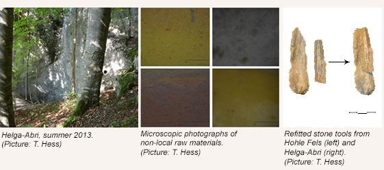
The rock shelter site Helga-Abri is situated in Ach Valley of Baden-Württemberg, on the Swabian Jura. It forms a protected area in close proximity of the famous cave site Hohle Fels. Excavations between 1976 and 1984 revealed several layers of occupation, dating from the Late Magdalenian to the Mesolithic. According to radiocarbon dates, the site was inhabited by Late Magdalenian hunter-fisher-gatherers between 15,000 cal BP and 14,500 cal BP. This period was marked by rapidly changing climatic conditions and important innovations such as the widespread use of bow and arrow, and domesticated dogs for hunting. In the framework of a PhD-study at the University of Tübingen, the stone tools found at the rock shelter are systematically analysed. The lithic technology of terminal Magdalenian groups can be characterised by the small size of artefacts (azilianisation), the occurrence of multifunctional tools, and a flexible reduction strategy. Backed points and asymmetric perforators (so called Zinken) display similarities to Magdalenian groups in the Paris Basin (facies Cepoy-Marsangy), and northern Switzerland (Technokomplex E). Furthermore, imports of exotic raw material over distances of up to 300 km, suggest a far-reaching contact network and extensive movements along the Jura Mountains during the Late Glacial. Geological similarities, leading to the abundance of chert-bearing layers, as well as possible campsites, facilitated migration between different regions. For the first time, it was possible to confirm previously observed typo-technological parallels between northern Switzerland and the Swabian Jura on the base of the lithic raw material. Finally, a refit of two stone tools from Helga-Abri and Hohle Fels, argues for a simultaneous occupation of the sites.
Contact:
Thomas Hess
University of Tübingen
Department of Early Prehistory and Quaternary Ecology
Room 111
Schloss Hohentübingen, Burgsteige 11
72070 Tübingen, Germany
thomas.hess@uni-tuebingen.de
Jochem Braakhekke / A multi-method reconstruction of the Last Glacial Maximum around Lago d’Orta & Glaciology Course in Spitsbergen / ETH Zürich
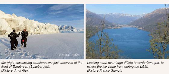
The support from CH-QUAT made it possible for Jochem Braakhekke to conduct extensive fieldwork around Lago d’Orta, northern Italy. Combining surface exposure dating, radiocarbon dating and a geomorphological analysis allows for a spatial and temporal reconstruction of the extent and termination of the Last Glacial Maximum (LGM) in the research area. The results of Jochem’s master thesis project add to the knowledge and understanding of the LGM on the southern side of the Alps.
Furthermore, part of the grant was used to participate in a winter school at the University Centre in Spitsbergen (UNIS). During an intensive four-week period with lectures and fieldwork at active ice margins, glacier physics, glacier modeling and remote sensing of glacial processes were discussed.
The reason to attend this course was to deepen the knowledge of ‘modern’ glaciology, whereas Jochem’s master project focuses on palaeoglaciology. Combining these fields leads to a broader understanding of the cryosphere.
Contact:
Jochem Braakhekke
jjm.braakhekke@gmail.com
Supervisors:
Susan Ivy-Ochs (ETH)
Irka Hajdas (ETH)
Giovanni Monegato (Institute of Geoscience and Resources, Italy)
Serdar Yesilyurt / Department of Physical Geography /
University of Ankara, Turkey
I am PhD student at Ankara University, Department of Physical Geography, Ankara, Turkey. My interests are Geomorphology, Quaternary Geology, Cosmogenic dating and Remote Sensing. I study Late Quaternary Glaciations in Eastern Anatolian Mountains, Turkey. My PhD thesis topic is Late Quaternary Glaciation in Kavuşşahap Mountains, Van: An Assessment in Terms of Regional Paleoclimate. I have been working as a guest PhD student at the University of Bern since December 2014. I came to Bern to learn how to work cosmogenic radionuclide dating and prepare my samples for AMS measurement.
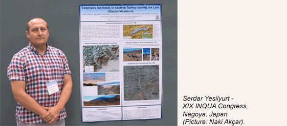
CH-QUAT supported my participation at the XIX INQUA Congress in Nagoya, Japan from 26 July - 2 August, 2015. I presented a talk on following topic: Extensive ice fields in eastern Turkey during the Last Glacial Maximum.
Author: Serdar Yesilyurt, Co-authors: Naki Akcar, Ugur Dogan, Vural Yavuz, Susan Ivy-Ochs, Christof Vockenhuber, Christian Schluchter.
At the beginning of the Last Glacial Maximum (LGM), equilibrium line altitudes of glaciers started to decrease as a result of changes in atmospheric circulation patterns. This decrease caused increases in the sizes of accumulation areas, thus, also glaciers in Turkey started to advance. The timing of the beginning of the advance depends on the altitude of the mountains and the size of the accumulation area. In eastern Anatolia, ca. 20 km-long glaciers descended to ca. 1400 m from the extensive ice fields of the Munzur Mountains. This large accumulation is larger than 500 km2 and consists of 800 cirques and 40 main glacial valleys. Munzur paleoglaciers reached a size of 730 km2 at their maximum extent. The size and magnitude of paleoglaciation in Munzur Mountains is the largest paleoglaciation area of Anatolia after Eastern Black Sea Mountains. Our aim is to reconstruct the chronology, and thus, the magnitude and frequency of glacier oscillations in eastern Anatolia.
To do that, we focus, in this study, on the Karagol Valley in the Munzur Mountains which contains numerous geomorphological records of paleoglaciers and with surface exposure dating. Karagol valley is located on the southern side of the mountains and opens to the Ovacik Plain. The Karagol glacier reached 13.5 km in length and descended to an altitude of 1350 m above sea level and left up to 160 m high lateral and terminal moraine ridges. We present here our geomorphological mapping and first dating results from this the valley. We collected 41 samples from calcareous boulders deposited on moraines for surface exposure dating with cosmogenic 36Cl. Cosmogenic exposure ages from eight of these samples indicate glacier oscillations around 18 ka at the end of LGM and ca. 14 ka during Lateglacial.
Contact:
Serdar Yesilyurt, PhD Student
University of Bern
Institute of Geological Sciences
Baltzerstrasse 1+3
CH-3012 Bern
Switzerland
serdar_yesilyurt@yahoo.com
http://www.geo.unibe.ch/research/quaternary_geology_and_paleoclimatology/index_eng.html
Carole Adolf / A novel technique to calibrate sedimentary charcoal accumulation rates with remote sensing data across Europe and its application under changing climate and vegetation /
Universität Bern
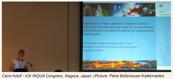
Die Unterstützung der CH-QUAT deckt meine Anmeldungs- und Übernachtungsspesen am XIX INQUA Kongress in Nagoya, Japan ab, wo ich mit einem Vortrag teilgenommen habe. Der Titel des Vortrages lautet: "Calibration of lake sediment charcoal particle influx with remote sensing data for a quantitative reconstruction of past fire activity at regional and local scales".
Autorin: Carole Adolf, Ko-Autoren: Willy Tinner, Stefan Wunderle
Mein Forschungsgebiet:
Die post-eiszeitliche Geschichte des Feuers in Europa wird oft durch das Zählen und Ausmessen von mikroskopischer Holzkohle in Pollen-Präparaten aus Seesediment-Sequenzen erschlossen. Es gibt jedoch nur wenige Studien, die eine Kalibrierung des Mikroholzkohle-Eintrags in Seesedimenten mit beobachteten Feuern durchgeführt haben. Dies ist jedoch notwendig, um die holozäne Feuergeschichte quantitativ rekonstruieren zu können und so wichtige Grundlagen der Feuer-Ökologie und -Bewirtschaftung für Entscheidungsträger zu liefern.
In unserer Studie vergleichen wir den jährlichen Eintrag von Mikro- und Makroholzkohlen (Influx) in Seen mit grösseren, in einem Umkreis von bis zu 150 km liegenden Feuern, die durch MODIS Satellitensensoren registriert werden. Diese Beziehung wird anschliessend benutzt, um Regressionsmodelle zu berechnen, welche auf jahrtausend alte Seesediment-Sequenzen angewendet werden, um wichtige Feuerparameter, wie z.B. Anzahl, Fläche, Intensität und Entfernung, zu rekonstruiren. Dafür wurden 42 Standorte gewählt, die der räumlichen Kalibrierung dienen, indem möglichst alle Ökosysteme Europas durch Seen mit Sedimentfallen vertreten sind. Die Sedimentfallen werden zwischen 2012 und 2015 einmal jährlich während drei Jahren geleert und deren angesammelten Sedimente analysiert. Zusätzlich zur Kalibrierung im Raum mit den Sedimentfallen, wird eine Kalibrierung in der Zeit durchgeführt, in dem jährlich laminierte Sedimente von vier weiteren Seen mittels Gefrierbohrungen entnommen und anschliessend untersucht werden, um die Beziehung zwischen den Mikro- und Makroholzkohle-Einträgen mit Feuer während mehr als drei Jahren (ca. 10 – 15 Jahren) zu verfolgen.
Kontakt:
Carole Adolf, PhD Student
University of Berne
Institute of Plant Sciences
& Oeschger Centre for Climate Change Research
Palaeoecology Section
Altenbergrain 21
3013 Bern
Switzerland
carole.adolf@ips.unibe.ch
http://www.botany.unibe.ch/paleo/index.php
Päivi Rinta / Aquatic Palaeoecology /
University of Bern
CH-QUAT supported my participation on Symposium for European Freshwater Sciences in Geneva on 5.-10.7.2015, where I presented my work entitled “Multi-decadal variability in methane cycling in a small forest lake inferred from fossil zooplankton δ13C analysis” in the session “Ecological insight from palaeolimnology”.
Small humic forest lakes often have high methane (CH4) concentrations and high contributions of methanogenic carbon to their food web but little is known about temporal variability of CH4 cycling in these lakes and how it responds to environmental changes.
In our study, we reconstructed past variations in the importance of methane-derived carbon in the food web of a small boreal lake, Mekkojärvi, in Finland by analysing the stable carbon isotopic composition (δ13C) of chitinous zooplankton remains in the sediments.
Contributions of methanogenic carbon in lake food webs can be investigated using δ13C analysis due to the distinctly negative δ13C values of CH4. Since δ13C values of many aquatic invertebrates are reflected in their fossilizing chitinous structures, such as resting stages of Cladocera, some aspects of the past carbon cycling of lakes can be examined by analysing δ13C values of these fossil remains in lake sediments.
Contact:
Dr. Päivi Rinta
University of Berne
Aquatic Palaeoecology
Institute of Plant Sciences
& Oeschger Centre for Climate Change Research
Palaeoecology Section
Altenbergrain 21
3013 Bern
Switzerland
paivi.rinta@ips.unibe.ch
http://www.botany.unibe.ch/paleo/index.php

Anne Claude / Exogene Geology /
University of Bern
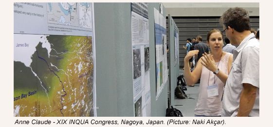
Die Unterstützung der CH-QUAT deckt meine Anmeldungs- und Übernachtungsspesen am XIX INQUA Kongress in Nagoya, Japan ab, wo ich mit einem Vortrag teilgenommen habe. Der Titel des Vortrages lautet: "Cosmogenic nuclide dating of proximal glaciofluvial gravels in the northern Swiss Alpine Foreland and inferred incision rates"
Autorin: Anne Claude, Ko-Autoren: Naki Akçar, Susan Ivy-Ochs, Fritz Schlunegger, Peter W. Kubik, Marcus Christl, Christof Vockenhuber, Meinert Rahn, Andreas Dehnert & Christian Schlüchter
Depth-profile dating is based on the decrease in production of cosmogenic nuclides with depth following known physical principles. For this method, at least four sediment samples have to be collected in a vertical profile and analysed. Then, modelled production depth-profiles are fitted to the measured nuclide concentrations with MATLAB® using Monte Carlo simulations A depth-profile age is calculated based on the best-fit. This method requires sampling of geological layers in artificial outcrops, preferably with a flat topped landform in order to guarantee that the surface of the deposit has remained as undisturbed as possible and that the surface can be related to a specific landscape forming process.
The goal of this study is to use depth-profile dating to reveal the chronology of the oldest Quaternary units in the northern Alpine Foreland. These deposits are called Deckenschotter (cover gravels) and are proximal braided river sediments which cover Tertiary Molasse or Mesozoic bedrock. Here, we focus on the three sites at Mandach (canton Aargau), Stadlerberg and Irchel (canton Zurich). All studied outcrops are abandoned gravel pits. At Mandach, four sediment samples, and at both Stadlerberg and Irchel, seven sediment samples were collected for cosmogenic 10Be analysis. The gravels at Mandach yielded an age of approximately 1 Ma and the deposits at Stadlerberg approximately 2 Ma. First results of the modelling of the sediments at Irchel suggest an age less than around 1 Ma. Our results show that the depth-profile dating method is appropriate when geological setting and methodological requirements match.
Contact:
Anne Claude, PhD Student
Institute of Geological Sciences,
University of Bern,
Baltzerstrasse 1-3,
CH-3012 Bern
anne.claude@geo.unibe.ch
http://www.geo.unibe.ch/research/exogene_geology/research/index_eng.html
Marlène Lavrieux / Eawag - Swiss Federal Institute of Aquatic Science and Technology /
Duebendorf, Switzerland
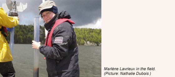
CH-Quat granted a financial support to Marlene Lavrieux for attending the XIX INQUA Congress in Nagoya, Japan from 26 July - 2 August, 2015. She presented a talk on following topic:
Tracing early farming impacts on soil using the age of terrestrial biomarkers deposited in lake sediments
Human activities have accelerated the natural erosional processes of soil to a critical point, so that the reservation of soils now becomes a major challenge. To accurately assess anthropogenic impacts on soil, information is needed on organic carbon dynamics before farming started, as well as how it changed with the evolution of agricultural practices. These impacts can be documented by investigating lake sediments, which are reliable continuous high-resolution archives integrating the natural and anthropogenic conditions that prevailed in the catchment.
This pilot study aims at evaluating how the development of agricultural practices impacted soil degradation. The method presented by Dubois et al. in session H10, using compound-specific radiocarbon analysis, was applied on a sediment core retrieved in Lake Joux (Jura Mountains, Switzerland). In this area, human pressure on the environments remained marginal until the 14th century. Strong transformations of the landscape (e.g. deforestation, bogs draining, and then industrial development) occurred from that time on in consequence of an extensive settling of the valley. Information provided by the different proxies (magnetic susceptibility and X-ray fluorescence measurements, high-resolution pictures, radiocarbon dates on macrofossils and biomarkers) illustrate the evolution of anthropogenic activities in the area.
Contact:
Marlène Lavrieux
marlene.lavrieux@eawag.ch
